

Open Data
Browse the public satellite datasets available in Tilebox, ready to use for prototyping and building your applications before your own data is available.
On top of access to your own, private datasets, Tilebox provides access to a growing number of public datasets. These datasets are available to all users of Tilebox and are a great way to get started and prototype your applications even before data from your own satellites is available.
Accessing Open Data through Tilebox
Accessing open datasets in Tilebox is straightforward and as easy as accessing your own datasets. Tilebox has already ingested the required metadata for each available dataset, so you can query, preview, and download the data seamlessly. This setup enables you to leverage performance optimizations and simplifies your workflows.
By using the datasets API, you can start prototyping your applications and workflows easily.
Available datasets
Copernicus Data Space
The Copernicus Data Space is an open ecosystem that provides free instant access to data and services from the Copernicus Sentinel missions.
Tilebox currently supports the following datasets from the Copernicus Data Space:
The Sentinel-1 mission is the European Radar Observatory for the Copernicus joint initiative of the European Commission (EC) and the European Space Agency (ESA). The Sentinel-1 mission includes C-band imaging operating in four exclusive imaging modes with different resolution (down to 5 m) and coverage (up to 400 km). It provides dual polarization capability, short revisit times and rapid product delivery.
Sentinel-2 is equipped with an optical instrument payload that samples 13 spectral bands: four bands at 10 m, six bands at 20 m and three bands at 60 m spatial resolution.
Sentinel-3 is equipped with multiple instruments whose data is available in Tilebox.
OLCI (Ocean and Land Color Instrument) is an optical instrument used to provide
data continuity for ENVISAT MERIS.
SLSTR (Sea and Land Surface Temperature Radiometer) is a dual-view scanning
temperature radiometer, which flies in low Earth orbit (800 - 830 km
altitude).
The SRAL (SAR Radar Altimeter) instrument comprises one nadir-looking antenna,
and a central electronic chain composed of a Digital Processing Unit (DPU)
and a Radio Frequency Unit (RFU).
OLCI, in conjunction with the SLSTR instrument, provides the SYN products,
providing continuity with SPOT VEGETATION.
The primary goal of TROPOMI is to provide daily global observations of key
atmospheric constituents related to monitoring and forecasting air quality,
the ozone layer, and climate change.
The Sentinel-6 mission represents a groundbreaking advancement in Earth observation, providing invaluable insights for scientists, environmentalists, and stakeholders worldwide. At the heart of this mission is the cutting-edge radar altimeter instrument, designed to measure sea surface height and monitor key oceanographic parameters with unparalleled accuracy. The Sentinel-6 satellite collects precise data by employing advanced radar technology, allowing for a comprehensive understanding of sea level variations, ocean currents, and climate patterns.
United States Geological Survey (USGS)
The United States Geological Survey (USGS) provides a wide range of Earth observation data, including Landsat data, which are also available as open data through Tilebox.
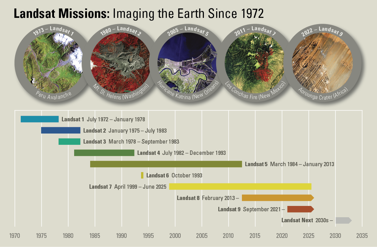
Landsat-1/2/3 carry the Multispectral Scanner (MSS) instrument, which measures in the VIS and NIR portions of the spectrum. Its images have 79 m spatial resolution.
Landsat-4/5 carry both the Multispectral Scanner (MSS) which measures in the VIS, NIR and SWIR portions of the spectrum in a 30m spatial resolution, and the Thematic Mapper (TM) instrument, which measures in the thermal-infrared band in a 120 m spatial resolution.
Landsat-7 carries the Enhanced Thematic Mapper Plus (ETM+) instrument, which measures in the VIS, NIR and SWIR and thermal-infrared portions of the spectrum. Its images have 15-60 m spatial resolution.
Landsat-8/9 are part of the long-running Landsat programme led by USGS and NASA and carry the Operational Land Imager (OLI) and the Thermal Infrared Sensor (TIRS). The Operational Land Imager (OLI), on board measures in the VIS, NIR and SWIR portions of the spectrum. Its images have 15 m panchromatic and 30 m multi-spectral spatial resolutions along a 185 km wide swath, covering wide areas of the Earth’s landscape while providing high enough resolution to distinguish features like urban centres, farms, forests and other land uses. The entire Earth falls within view once every 16 days due to Landsat-8/9’s near-polar orbit. The Thermal Infra-Red Sensor (TIRS) instrument on board is a thermal imager operating in pushbroom mode with two Infra-Red channels: 10.8 µm and 12 µm with 100 m spatial resolution.
Alaska Satellite Facility (ASF)
The Alaska Satellite Facility (ASF) is a NASA-funded research center at the University of Alaska Fairbanks. ASF supports a wide variety of research and applications using synthetic aperture radar (SAR) and related remote sensing technologies.
Tilebox currently supports the following datasets from the Alaska Satellite Facility:
European Remote Sensing Satellite (ERS) Synthetic Aperture Radar (SAR) Granules
Umbra Space
Umbra satellites provide up to 16 cm resolution Synthetic Aperture Radar (SAR) imagery from space. The Umbra Open Data Program (ODP) features over twenty diverse time-series locations that are frequently updated, allowing users to explore SAR’s capabilities.
Tilebox currently supports the following datasets from Umbra Space:
Time-series SAR data provided as Opendata by Umbra Space.
Satellogic
Satellogic offers the EarthView dataset, which includes high-resolution satellite images captured over all continents. The dataset is available through Tilebox as a spatio-temporal dataset.
High resolution satellite images provided as Opendata by Satellogic. The dataset provides Top-of-Atmosphere (TOA) reflectance values across four spectral bands (Red, Green, Blue, Near-Infrared) at a Ground Sample Distance (GSD) of 1 meter, accompanied by comprehensive metadata such as off-nadir angles, sun elevation, and other pertinent details. Users should note that due to an artifact in region delineation, a small number of regions present overlaps.
Wyvern
Wyvern offers a constellation of satellites providing high-resolution, hyperspectral imagery. They offer products from their Dragonette constellation as open data, which is also available through Tilebox as a spatio-temporal dataset.
High resolution, hyperspectral imagery provided as Opendata by Wyvern.